HISTORICAL SITES on the Foresthill Divide
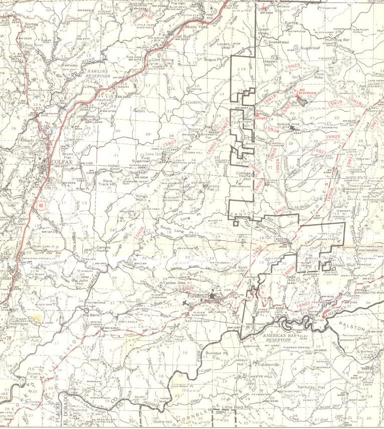


Mouse over the red stars to see information
about those locations. Use mouse scroll
wheel to scan articles.


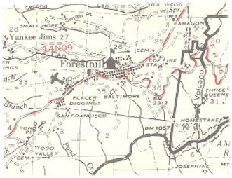
Forest Hill (Foresthill) and Jenny Lind mine
Forest Hill was located on a broad ridge between the North and Middle
Forks of the American River on the gold-bearing gravel bed of an ancient
river. In the spring of 1850, miners came to the Forest Hill Divide in large
numbers. There was one route from Auburn through Yankee Jim's and one
from Coloma. At the junction of these trails, the Forest House hotel and
trading post was built.
The combined production of all the mines in the Forest Hill area was
estimated at $10 million by 1868 with gold selling for $16 an ounce. In the
1860's, there were about 125,000 feet of hard-rock tunnels dug into the
hillsides in, around and under Forest Hill. By 1857, this area had become
an important center for trade among the many gold camps on the divide.
In 1862, the Hardy-Kennedy building was erected - the first fireproof store
in Forest Hill. This building, now known as the Langstaff building, is still
being used by the merchants of Foresthill. By 1880, Forest Hill was one of
the largest towns in Placer County. The town had an 80-foot wide main
street befitting such an important place.
Jenny Lind mine: In 1852 the Jenny Lind Mine, which produced over a
million dollars in gold, was discovered. Severe storms during the winter of
1852-53 caused a huge landslide, exposing an abundance of gold at the
head of Jenny Lind Canyon—yielding $2,000 to $2,500 in gold every day.
Jenny Lind Canyon is now called Snyder Canyon.
![[x]](index_htm_files/close.png "Close")
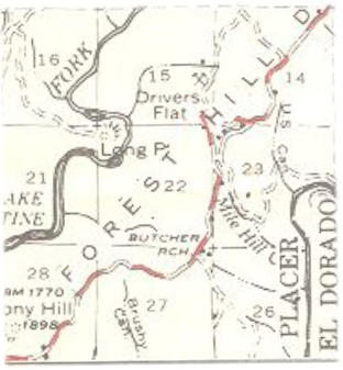
Butcher Ranch and Grizzly Bear House
Butcher Ranch was originally a farming settlement located on the Stony Hill Turnpike that ran
along the divide between the North and Middle Forks of the American River. During the gold
rush, it had a post office, a drugstore, two hotels, a blacksmith shop and a carpenter's shop,
and a population of 250.
Grizzly Bear House was an overnight stop for travelers, and was mentioned in 3 Years, in
California by J.D. Borthwick, first printed in 1857.
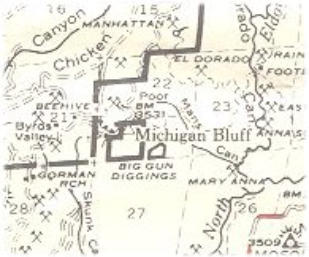
Michigan Bluff
Located adjacent to the Big Gun Diggings which was the site of a major gold find.
Hydraulic mining was used extensively in this area until 1884 when it became strictly
regulated. Leland Stanford sold goods here to miners. He later went on to build the Central
Pacific railroad and was elected Governor of California. He was the founder of Stanford
University.
Last Chance
Mining community established in 1852, east of Michigan Bluff. There is a narrow 14 mile
trail along steep mountainsides between Last Chance, Deadwood, and Michigan Bluff
which was listed on the National Register of Historic Places on June 26, 1995, and is now
a segment of the Western States Trail. This trail, once a toll-trail, crosses two deep river
canyons and is the most arduous part of a longer route used by 19th century gold miners.
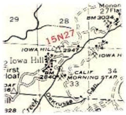
Iowa Hill
Located on a ridge between the American River and Indian Canyon, Iowa Hill began growing in 1853 around the
Jamison Claim, famous for its gold production. The Jamison was drift mined and later hydraulically mined. The North
Star Mine in this area was the first in the state to use a stamp mill to break up cemented gravel that was extracted
from the mine. At one time during the boom days, there was a proposal to divide Placer County and make Iowa Hill
the county seat. During the area's good times, daily stages ran to Illinoistown (now Colfax) and connected with
stages for Dutch Flat and Auburn. The road to Colfax (now paved) is still used today and is still very steep and narrow
- a real thrill ride, especially when meeting oncoming traffic.
An 1861 historian said "The business portion of Iowa Hill consists of three large grocery stores, four hotels, five dry-
goods and clothing stores, one fancy store, three variety stores, one brewery and soda factory, two hardware and
tinware stores, and two butcher shops, besides the usual number of bowling alleys, billiard and lager beer saloons.
Iowa Hill also has a splendid Catholic Church, a Methodist Church, a Masonic Lodge, and a Lodge of Independent
Order of Odd Fellows, also a public school and a theater."
Three times, the town was destroyed by fire. Now the town consists of a one-room schoolhouse for kindergarten
through 8th graders, a volunteer firehouse, community club and park and a charming combination store, post office,
tavern and café. It still does not have telephone or electric service, public water supply or daily mail service. The local
graveyards provide a fascinating glimpse of the past as there is a log telling of the fates of those who are buried
there. Several miners died as a result of a dam breaking upriver during a rainstorm. Mining was clearly a dangerous
occupation and caused many premature deaths.
Deadwood
Settled in 1852, today only a few scattered remains mark the spot where
this town once flourished. It is accessed by a trail from Michigan Bluff.
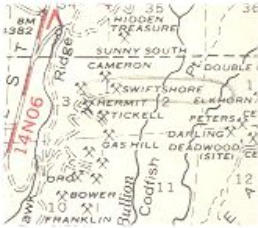
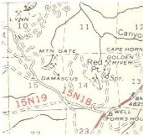
Humbug Canyon (Damascus)
This canyon was originally named Mississippi Canyon, but was renamed in 1850 to
Humbug Canyon by discouraged miners. Dr. D.W. Strong discovered gold in 1852 in
quartz gravel on a point between two branches of Humbug Canyon. This location was
originally known as Strong's Diggings until a post office was established with the name of
Damascus.
The Mountain Gate mine was in this area.

Shirttail Canyon
Sugar Pine Reservoir is located at the upper end of Shirttail Canyon. Shirttail
Creek flows into the North Fork of the American River just above the once
historic Barnes Bar. The canyon got its name when two men named Tuttle and
Van Zandt came upon an almost nude man mining along the water's edge. He
was wearing nothing but a shirt. The men asked the miner what this place was
called and he replied, glancing at his bare legs, "Don't know any name for it yet,
but we might as well call it Shirt-tail as anything else."
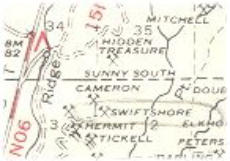
Sunny South (Hidden Treasure Mine)
On the south end of Damascus Channel
separated by a channel running across it,
another mine was established with the name
of Hidden Treasure. This location was called
the Sunny South because of its fine, warm
climate.
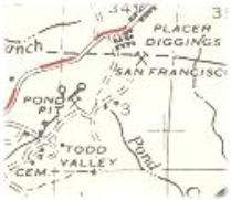
Todd’s Valley
A store and hotel were established here in 1849 by Dr.
Todd.
The remnants of the A. A. Pond & Co. mine, also
called the Pond Pit, is easily seen by those going to
the Waste Transfer Station in Todd's Valley.
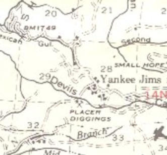
Yankee Jims
Hydraulic mining began in 1852 near Yankee Jim's. This method of mining used a monitor to spray water
under high pressure against the hillsides to wash away the dirt and gravel from an ancient riverbed. The
runoff was diverted through a sluice where the heavy gold settled to the bottom and was trapped in the
ridges.
The Duncan Hotel was built in Yankee Jim's in 1870 when mining was flourishing and was the oldest
landmark in the community until it burned in July 1929.
In 1850, a horse thief calling himself Yankee Jim discovered gold on a ridge between the North and Middle
Forks of the American River about three miles northwest of the already active gold camps at Forest Hill.
Paragon Mine: Owned by Abraham Breece and Judson Wheeler in the town of Bath,
just east of F.H. In the Paragon Mine, at Bath, Placer County, there are three distinct
determinable channels. First, the lowest and original, a blue gravel channel lying directly
on the country rock. Second, an upper channel one hundred and fifty feet above the first
in an elevation and having the same general line of flow. Between the two are alternate
layers of wash gravel, sand, and pipe clay. Third, a channel crossing and cutting through
the second, but not down to the first. This last is filled with a lava flow.
The Paragon grossed $13,000 per month in the 1880s. Paragon $2.65 million+
Red Point Mine: near Damascus and the Mountain Gate
Mayflower Mine: On a tertiary river channel. Mayflower $1 million